|
The first day on the trail would take us from the Backpackers camp across the Merced River from North Pines camp ground, elevation 4000' up and over Tuolumne Pass about 10,000' and then to Lower Cathedral Lake for the night. That was the plan. This presumed that we had driven up the day before, left our cache of 8 days of food and 14 days of fuel in Tuolumne Meadows, and then get dropped off in Yosemite Valley, Debbie was the designated driver. Caching was straight forward, but the Yosemite Valley traffic was horrific, and Debbie dropped us off on the north side of Sentinel Bridge, it took us the better part of an hour to get there from the El Cap meadow turnoff. From their Stephanie and I walked out to the campground and found a place to sleep... eating that night in the place formally known as Curry Village. 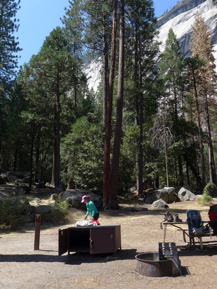 Site 8 at the Yosemite Valley Backpackers' camp. We got up early the next morning, had a quick breakfast, packed and were off to find the trail. While the start of the trail is listed as "Happy Isles" you get there in maybe a mile or so... 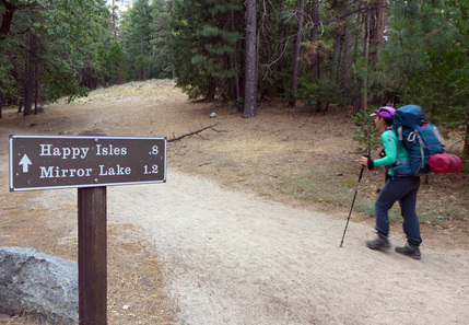 ...then onto the trail proper, sign and all. 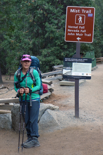 Our route would take us up the switch backs that depart the Mist Trail just beyond the bridge. Given our packs and the day we were facing, that seemed the most prudent plan. These ascend the slope to the Panorama Trail and then heads east contouring to the top of Nevada Falls, avoiding all the stairs. The top of Nevada Falls is at 6000' so we get 1/3 of our total altitude. A short break allowed for the appreciation of the magnificent Valley. 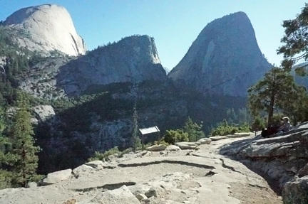 Rest stop on the Panorama Trail, Stephanie Hartouni image. At the outhouse located just beyond the upper junction with the Mist Trail we encounter the bedraggled group of hikers we started out with, they were a bit faster than us, but we definitely had a much better time. We greeted them and moved on. From here we climb up to the saddle between Half Dome and Cloud's Rest before moving east behind Cloud's Rest. Another 2000' elevation gain gets us to the trail junction down to Lake Merced, seemingly known ground. The part of the hike starts to become hot and dusty. Part of this has to do with the Meadow Fire of September 2014, I was climbing with Linda that weekend and we spied it from our route. 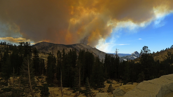 The Meadow Fire, September 7, 2014 from Olmstead Pt. 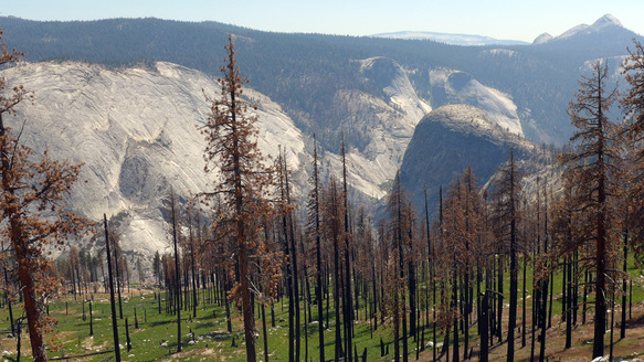 Looking down past the burned forest into the Merced River gorge at Bunnell Pt. with Mt. Starr King in the distance. The forest that once shaded the trail burned down, leaving us to toil up in the full Sun during the afternoon. This was the first of a number of stressful days as I worked out my hydration scheme. Stephanie was the champ going up hill, I felt every bit the old man I was, but my problems probably were always there, feeling ill not because of altitude, but because of exertion. The JMT eventually finds "the switchbacks" which ascends up to Sunrise High Camp. This turned out to be totally exhausting for me. We were running out of time for the day, and we were pretty worked. But not only that, a ranger we had met on the trail up, checked out our wilderness permit and eventually learned of our plan to camp at Lower Cathedral Lake without a bear canister. He was quite upset, but didn't cite us (we didn't have one with us, planning on eating everything) and said that either we should stay at Sunrise, or in the Tuolumne Meadows backpackers' campsite, each of which had bear boxes. If we did not we'd be in trouble! After quite a day we were happy to comply with his instructions. 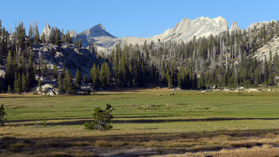 Meadow adjoining Sunrise High Sierra Camp, Matthes Crest in the background. The total distance was 14 miles (though Stephanie's GPS watch showed more, with a total elevation gain of 6960' and loss of 1590'. Our highpoint was at 9700' at 12.5 miles, so we were going uphill pretty much the whole day.
The day 1 kml file has a combination of the various bits of information, including the track from Stephanie's watch.
2 Comments
Planning for the trip seemed, to me, to be low key, simply because I've done it so much over the last 50 years of my life. My first trips, with the Boy Scouts, started when I was 10 year old. This casual approach probably wasn't the best, but Stephanie and I had only done weekend trips to get into "shape" for doing the JMT and for testing out our kit, and the food we'd bring. Stephanie's vegetarian diet didn't seem so unsurmountable to me, and she had a lot of interesting food choices that I figured would be interesting to try out. Getting an idea of just how much we'd eat was difficult. But first we'd need an itinerary. My idea was to try to do the JMT in 2 weeks. That's a number that seemed doable, but fast. Basically it came from a somewhat antiquated view of mine that we might be able to carry 2 weeks of food, and so we'd do the trip entirely self-supported. The reality of the JMT today makes that difficult unless the trip is very quick and the food required fine tuned. Basically this is because of the food storage requirements, that all the food has to be stored in some form of approved canister that prevents the bears from getting it. The canisters have a weight of roughly 2lbs, and a finite volume. This weight is roughly one day's food ration for one person. We were able to cram 7 days of food into each of 2 canisters, which had them weighing in at 16lbs each. Two weeks would have probably been prohibitively heavy. However, we would find that our planning over estimated the amount of food required. Our three trips in 2016 prior to the JMT were: May 28-29 to Buena Vista Pass in the southern edge of Yosemite NP, June 18-19 to Sadler Lake in the Ansel Adams Wilderness, and July 7-9 to Lake Merced from Tuolumne Meadows over Vogelsang Pass and back via Sunrise High Sierra Camp. Suffice it to say that we learned a lot on these trips, generated some anxiety about my ability to tolerate the physical demands of backpacking, and were great adventures on their own, taking me to parts of those mountains I hadn't been in before. But they didn't get to answer all the questions that we wanted to answer for the JMT.  Stephanie on our hike out to Buena Vista Pass. Snow was an issue this year! 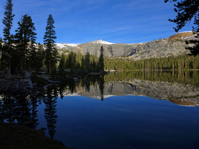 Sadler Lake in the Ansel Adams Wilderness. 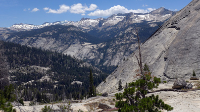 Looking down Fletcher Creek into Lake Merced valley. The JMT trip itinerary we came up with was pretty aggressive.
The resupply plan was to carry one day of food on the first day and pick up 8 days of food in Tuolumne Meadows. Then to resupply at Muir Ranch which had us picking up 4 additional days of food, which totaled 13 days of food. About one gallon of food was also cached at Tuolume Meadows, we carried a smaller container of 2 days for day 1. The first day is a monster day in terms of altitude. The second would be in terms of distance. After that we'd have to get in 8 to 10 hours of hiking at a rate suggested by our initial trips. That, at least, was the plan. We got together and bought food, and this had to be packaged, four days worth sent off to Muir Ranch 3 weeks before our pickup date. 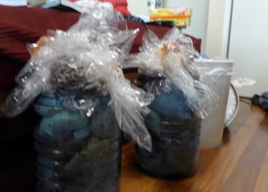 Food divided into the two bear canisters and one resupply bucket. 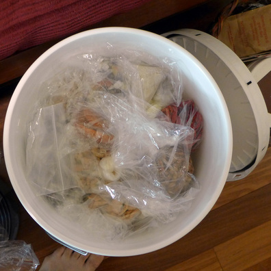 4 days for 2 people ready to ship. The July trip was the last backpack. We trained until the week before, then we rested getting ready for day 1.
Sometime a year or so ago, my daughter Stephanie asked whether I would be interested in hiking the John Muir Trail. I replied: yes! but on the condition that she obtain the various permits. The permit process is detailed, complicated and not entirely straight forward requiring a degree of persistence I find hard to muster in my old age. She did manage to eventually secure the permits, including a Half Dome permit, for our proposed attempt to do the entire trail in 2 weeks, which was my idea, from entering on August 7th and exiting on the 19th. You might notice that the dates in the title don't match, and I'll say now that we spent 8 days on the trail and then exited early. The reasons will revealed later in this story. Our "going-in" strategy was to minimize the total amount of food we would take, minimize the resupply, and go for distance each day. The trail is something like 210 miles long, if you hiked it on average 2 miles per hour, then you'd need something like 105 hours, and for two weeks (or say 13 days) you'd have to hike a little more than 8 hours a day to make it. This was the first long backpacking trip we have taken together, all the preparation trips and everything else took place over 3 days or less. Planning was complicated because we needed to agree on food, her diet and mine are very different, and finally she is more than 20 years younger than I and is fit from her trail running, I haven't taken a long trip like this for over 20 years. But the whole idea of the trip was to share this sort of adventure together, not only as father and daughter, but also as a team going on an adventure. Stephanie grew up with me going off on these sorts of adventures, but only participated in one, when she was 7 years old, a trip to Tuolumne Meadows to meet up with another of my adventure partner, Mike Church, at the Church annual family get together. Mike and I were graduated students together, and also climbing partners. That was in the mid 1980s. 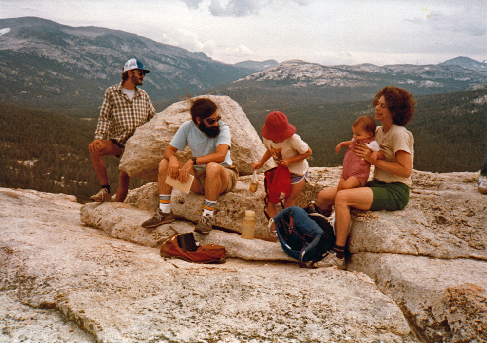 Summit of Lembert Dome, Tuolumne Meadows, CA. From left to right: one of Mike's brothers, me Stephanie and Sue Mendelsohn (Mike's wife) holding Judith Church. Stephanie doesn't recall much about that trip. She had forgotten it was in Tuolumne Meadows. She remembers not liking the mildewy smell of my tent, camping in the dirt, the hiking every day, etc... but she was a champ and for me it was a fun to get to go out with her for a week. Parents hope they can share their passions with their kids, but Stephanie didn't want to do that again, until these past few years. Another reason to say "yes" so quickly was that my father, who had inspired me to adventure, had expressed a hope that he might go out with me on a trip, that we could share this together. Unfortunately, we never found the time. I remember seeing this image in a book of photos from his youth: 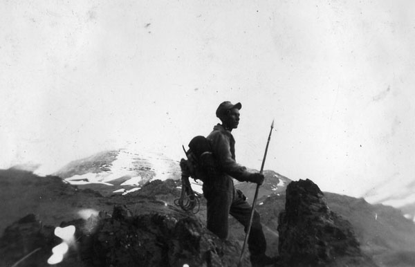 Ed Hartouni (my father) climbing in the Alborz mountain range in northern Iran. When Stephanie was born my father reminded me of my responsibilities and strongly advised that I should not continue to engage in risky behavior. He didn't approve of my activities and let me know his feelings. When he'd ask "are you still climbing?" I'd reply "not as much as I'd like to," which was truthful if a bit ambiguous. Eventually, however, he became interested, wanted to know about the new equipment, the various technical details, and just what it was we were doing out there. It was around this time that he thought it would be fun to take a little adventure, we me. But we take our youth for granted, and hardly notice that we're not able to fulfill our desires, whether physically or mentally. In the end we never made that trip. Given the opportunity to go with Stephanie on an adventure was something I wasn't going to pass up, and even though I'm in my 60s, I thought I'd be able to take a long walk with her through the Sierra Nevada. The lesson from my father, and from other friends was well learned: don't put these things off to an unknowable future. The last bit of this introduction was my previous attempt at "doing" the John Muir Trail, which was the summer of 1974. Stephanie became aware of this when we picked up the Wilderness Permits at Big Oak Flat on Saturday, August 6. The NPS ranger asked if we had ever attempted the trail, he was about to give "the briefing." I replied "yes, but probably before you were born" (which ended up being true, him 1980s). Later in our trip Steph asked about this first attempt after dinner at Mono Creek Junction. That summer I had made a bit of money taking care of the kids whose parents left on an extended vacation. That was the summer after meeting Debbie. With those funds I hatched a plan to do the John Muir Trail, buying the gear from various Berkeley "outdoor" shops, the Ski Hut being the most famous. I still have some of that gear after all these years. 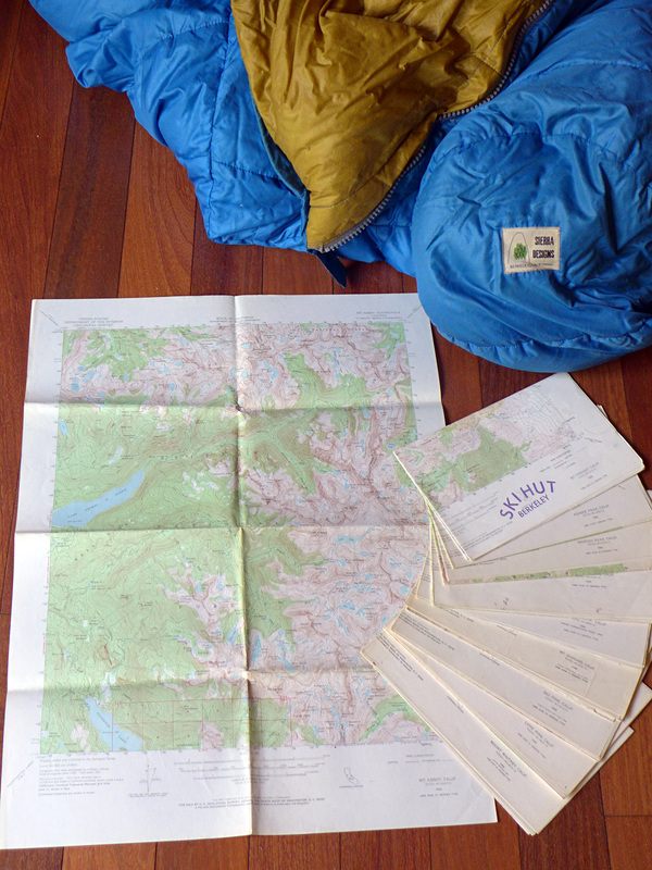 My Sierra Designs down sleeping bag and a complete set of USGS quads for the John Muir Trail. Debbie and our friends David and Stephanie (who was Debbie's roommate in the UCB dorms and a dear friend, after whom our daughter was named) dropped me off in Yosemite Valley. After crashing at Camp 4, being rousted for sleeping "out of bounds," shouldering the pack, I was off.
I didn't get very far, not having trained for the hike, a couple of years of study didn't translate to the physical preparation for climbing, and also the challenge in keeping the motivation up when hiking solo, I turned back not far from the Valley's rim. Calling my father to come and pick me up, I abandoned the trail and returned home for the duration of the trip. While that seemed like a "failure" at the time it was, in the end, a gift. That time at home I spent with my mother and the rest of the family. My mother died suddenly, an event I would have missed had I been hiking on the trail. My lasting memory of her was saying "good-bye" the morning she went off to the church meeting where she died. So the John Muir Trail mixes many of my life lessons, most importantly, of living in the moment, following your passions and not differing to later. The other important lesson is that a well chosen adventure seldom follows our plans, I didn't tell Stephanie this before we left, but part of the adventure has us sharing these life events, almost as an idle after thought, when sitting around camp waiting for the moment to retire to bed to recharge for the next day's labors. These confessionals are a familiar part of those journeys, and part of the bond forged with our partners on those adventures. |
AuthorEd Hartouni is a physicist and a climber who lives in Livermore, California. ArchivesCategories |
 RSS Feed